Wednesday, October 13, 2010

In Hotlanta dreaming of cooler climes....


Kids know how to keep it cool during heat wave- the fountains of Centennial Olympic Park in downtown Atlanta - photo courtesy of Channel 5 


Having just returned from my second trip up to arctic Alaska, I'm not happy camper about the weather situation here in Georgia this summer into early fall. 


A high pressure dome has been sitting over the southeast, including Atlanta, for the last month - paradoxically, no rain but over 80% humidity, so very muggy and hot - Atlanta had temperatures in the mid to high 90s for over 15 days in a row in September; it's has 'cooled' off to mid-80s for October. Southern heat is a real 'thing' pressing down on you - you feel as though you are walking through molasses and all your energy drains out through your toes. 


I've been thinking a lot since I returned from Nome about the  hauntingly similar geography of the Alaskan Arctic tundra and the highlands of Scotland.  The landscape I've seen thus far around Savoonga is comfortably resonant of perhaps its near sister-island halfway around the world, at nearly the same latitude.  Even if not the highest peaks, both islands have formidable crags scattered across the interior with some year round snow patches, glacial streams of Savoonga and brae burns (pretty streamlets in the highlands) of Scotland run to the sea in great wet spots (the famous peat of Scotland and Ireland are but bogs dried by time and pressure).


Map showing only Scotland; Britain takes up the bottom half of UK.  
If you click on the picture, you will be able to see watersheds and names. 
 The Shetland islands are northernmost part of Scotland 
at 60 deg 44 min North and 51 West


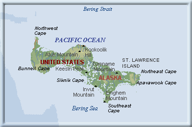
St. Lawrence Island - Savoonga is located at the point labeled Kookoolik Hill.
Savoonga is 63 deg 41 min North and 170 deg West  


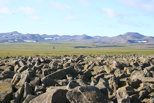
Kitnik talus field, St. Lawrence Island, AK
Photo by 'Eric' at EpicTrip


Beinn Deag Mor of Scottish Highlands


The land, both Beringia and Scotland, is the dawn of time exposed - developing not long after, geologically speaking, the Precambrian shield, hardly clothed at all with much plant life to speak of.... but that which there is displays beautiful hues in the fall - one would be hard pressed to differentiate tundra willow, alder, birch and berries from moorish heather at that time of year, even the shaggy beasts seem to share some characteristics.  


Fog in the Highlands,fairly typical day 
- notice the red heather on the moor


Wild highland cattle


Cliffs of Moher of Scottish Highlands

Left: Ovibos moschatus - muskoxen common to Seward peninsula


Puffins on cliffs of St Lawrence Island              


Even the summers of that better half of the United Kingdom are similar to St Lawrence Island --typical daily summer forecast in Scotland:  "most cloudy, high of 45 degrees, occasional bright spots "(bright spots were never sunshine, just thinner cloud cover - if temperatures reached 70 degrees,it was a heat wave and people dropped like flies)

You may have guessed by now I have a strong connection to this place - my father's ancestors are of Scotland - the Dees on his mother's side from the River Dee (inland from Peterhead) and the lowland Kerrs of my grandfather Carr (variant spelling) may have dwelled further to the south, perilously close to Britain.  Carr: a word in itself that means a certain type of wetland, alders, birches and willows. Hmmm....no wonder I always feel most at home near water!

Both islands surrounded by fiercely capricious oceans - my father, who was a man of the sea his whole life, told me that when he was out there building some of the first offshore oil rigs in the North Sea, not uncommon to see waves reaching 80 feet high.  

But in the Arctic, when the 'gales of November come blowing' (tip of the hat to Gordon Lightfoot who paid great homage to men of the sea),  it is time to put aside similarities. As I write this, it has been snowing lightly but steadily in Savoonga for several days and there is not much change in the forecast.  I am probably not well-prepared for this and will have to rely on the good people of the village to keep me from making really stupid mistakes and getting lost or hurt.  I may tie a line from my house to the clinic.


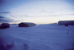
This is actually a winter scene from Gambell, village to the west of Savoonga.

Somehow I don't think a polartec vest from
L. L. Bean is going to be all that effective.


Saturday, September 25, 2010

Next stop Unalakleet and Savoonga


Leaving Nome in a fog - literally and figuratively
 
I don't have all my pictures back from this leg of recent trip, post these later.  Norton Sound (tribal health agency out of Nome) sent me to two villages for consideration while interviewing with them.   Village providers can be medical doctors or midlevel providers like me (nurse practitioners or physician assistants); the clinics are staffed up with health aides who have been trained specifically to handle most minor problems but always jump for joy when a provider is on board.  They take 'first call' nights and weekends, but if they feel problem requires it, they call provider in.  Trauma unfortunately rather common, often related to alcohol and ATV and snowmobile accidents. 

Very critical patients can be Med-Evac'd out to Nome (at great cost, about $15,000 trip) or kept in clinic "ER" until next commercial flight, twice a day, bush planes - your patient may be seated next to sled dogs in crates. Weather is another factor.  Always possible that if you don't send patient out in time, you will be 'socked in' by ice-fog, blizzards, high winds, low ceilings, etc. and you'll be winging it with an "ICU patient" in the clinic for three days until it clears.

The bush plane was Cessna today - makes two little 'stops' - picks up someone at St. Michael's and drops off packages at another village, Stebbins, on runway of gravel, I swear looked to be about 600 feet long! 


Headlands - coming into St. Michaels


Next stop, Unalakleet is on the mainland, tucked inside Norton Sound further south.  Trying very hard to be 'regional' hub, a mini-Nome, as it were. They were frantically laying macadam roads while I was there - trying to beat onset of winter which stops all such projects. I asked if they were laying special sub-surfaces because of frost heave; the surprising answer was "NO."  Boy, are they gonna be sorry; on the other hand, there's the economic stimulus from unending road repairs.

Again, beautiful volcanic rock beaches for miles, lots of driftwood, seaglass, other storm detritus. 


Coming into Unalakleet


Savoonga...whole other world.  On island of St. Lawrence, in middle of Bering Sea, closer to Russia than mainland U.S.   Not a small island and very mountainous interior with snow patches all year round; one other village about 70 miles away (should you be brave enough to try sno-go trails), Gambell. 

More on St. Lawrence Isle in next post.

Friday, September 24, 2010

Nome Home!

World's largest gold pan - life-sized bronze statues to the right of gold miners.


Nome feels less like Arctic Alaska and more like the final western frontier!  When the world's basket is given a good shaking, all the nuts fall to the bottom and land in Nome, last repository of the wild, woolly, weird and dreamers... since Australia has become civilized.

Nome sits on the southern shore of the Seward Peninsula, somewhat protected by Norton Sound from the heart of the Bering Sea to the west. Nearly 40 miles of beaches of black, volcanic rock, stones the size of peas to large boulders, smoothed by time, pressure and friction; miles of driftwood size of huge timbers to little nubs.


The Gnarly Oak Finish Line sits next to Nome's City Hall most of the year 
and is hauled out into middle of street for the race in March.


Everyone knows Nome for the Iditarod and well it should...forget Mission Impossible and Tom Cruise!  This is real edge-of-your-seat, nail-biting story of race to get diptheria serum from Seattle via Anchorage to stricken-Nome during a blizzard in early 1900s - planes had open cockpits then and couldn't fly in such bad weather; a train brought serum as far as Nenana- above Anchorage- and from there teams of mushers and their heroic dogs took the 20 pound life-saving package in relays, a trip over some of the world's harshest landscapes in midwinter.  This was not the age of Gore-tex.

The lead-dog Balto is most well-known, a bronze statue of him stands in NY's Central Park and movies have been made about him -- but the librarian, Nadiya, at the Nome Museum tells me Balto was considered a somewhat weak lead-dog; however, he did get his team across a treacherous stretch of frozen Norton Sound just prior to the ice breaking up, was last into Nome and is thus remembered.

Seppala and Togo
Photo credit to NorthernLightMedia website
See "Much Ado About Mushing" link
  
Musher Leonardho Seppala and his dog Togo are credited with the most harrowing segment of the nearly 700 mile race but that fact has been lost in mists of time. 

Today's racers must make it down Front Street under the burled Arch to win the Iditarod after a 1,000+ mile long race, after a ceremonial start in Anchorage. 


And, far from its origins, the Iditarod is now called "The Mardi Gras of the North" - let your imagination run with it. 

Ovibos moschatus - otherwise known as musk ox. 
This is mixed herd with youngster between two adults on the right. 
Photo by Finnskimo taken outside of Nome

About 3000 or so people call Nome home, along with a rather large herd of muskoxen that have made themselves comfortable this summer on the outskirts of town (tundra cows, yummm). 

Mostly misty and cool while I was there - only sunny day of the week was time spent in village of Unalakleet, further south on Norton Sound.

Looking east along Nome's beach


That's Nome's harbor in the distance, such as it is, made of local materials, volcanic boulders and gravel; it can be a busy place at times when
cruise ships, NOAA, US Coast Guard and barges tie up here.

4 foot rollers coming in with fog and clouds; balmy 45 degrees


This is not what Front St. looks like in March
when the mushers cross the finish line.


In the park stand two umiaqs - boats once used for many centuries by hunters - walrus hides are stretched over the frame (actually half a hide, I was told); apparently, some villagers in the NW burroughs still use the traditional umiaq in ceremonial hunts.  That's a whale vertebra in front on the ground. To give you sense of scale, the umiaq frames are about 20 ft long and stand on poles about 8 feet tall.  This should give some appreciation for the courage of the men who took to sea against the mighty leviathian - the village's very existence depended on a successful return.


A longer view to capture the juxtaposition of the ancient and the modern (kids on their honda ATVs and playing on swingsets).  Kids joyfully running around the grassy field playing frisbee just beyond those incredible testaments to their ancestors' life-link to the sea.  

Below are views of the autumn tundra from the Teller Road. Nome is unique in the Northwest Burroughs because it has a 300-mile road system - they don't really go anywhere but can get you out of town when you've had enough!  The colors are true....purples, golds, yellows - reds show well with sunshine, not in good supply today. 


The other interesting point I wanted to make is that the tundra is not barren and FLAT - it's quite rough and busy!  Any hike would be quite challenging without a path.  There are tangles of willow, alder and birch about hip-high that probably only a moose or bear could get through easily.  Photo above is taken from a camp on banks of small river that runs to Norton Sound.  Seems everyone has a 'camp' in Alaska, to get away from the hustle and bustle of the 'city'.


Interesting historical artifact for those of us older than 50:  up on the hill in the misty fog you can barely make out the now-defunct DEW line structures - it was how we monitored Russia during the Cold War.  And -- I'm not a Sarah Palin fan, and neither are many Alaskans - but you really can see Russia from certain places in Alaska!
More about that in the next post. 
 

Kotzebue


Somewhat typical Arctic village - not exactly 'Northern Exposure';   Kotzebue won't make it into Better Homes & Garden but I admire the folks;   they don't throw anything away because you never know when you might need it, can't get it

30 miles north of the Arctic Circle on the Northwest coast of Alaska, Kotz sits on spit of land made of gravel deposited by the Noatak River; the village is nestled in bosom of Kotzebue Sound which opens to the Chukchi Sea and Arctic Ocean; fly-in village - no roads; barges can access the village during summer to early fall. 

Sound freezes over in the winter and protects the shoreline from storm waves, but with warming global temperatures, ice sheets unpredictable, break up early and storms pound the gravel shore of the village, eroding Front Street, literally eating away at the town. Same thing happening all along the Alaskan northwest coast - melting permafrost, melting ice sheets, worsening storms - google villages of Shishmaref, Kivalina...

Only stayed few days, another job interview awaits in Nome.  But here are a few pictures: 

flying into Kotzebue you can see how much of the peninsula is really all wetlands - circular 'ponds' typical for tundra


Kotzebue International Airport -- haha, gravel strip about 1000 feet long.

Caribou antlers tossed casually onto roof tops everywhere - many here depend heavily on subsistence hunting; sno-go's sit on rooftops waiting for the winter


Me with silly grin taking self-portrait on Front St. with Kotzebue Sound and 'foothills' of the Brooks Range to the north in the background (that corrugated wall you see is the new construction being done to protect village from being washed away)
 

On oddity, garbage huts are necessary, not because of marauding dogs (sturdy dogs are everywhere but always tied up near front door of house) but because of marauding winds.  Apparently, this particular household having problems with someone who has been donating special kind of trash....clickon picture for closer view of the owner's 'beware notice'.


click on photo to read the fine print!


On to Nome and the Seward Peninsula...

Tuesday, September 14, 2010

Starting over

After shooting myself in the foot earlier this year and an intense five months of job-seeking, have found myself headed for Alaska...not just any Alaska, but out-in-the-Bering-Sea Alaska.  Job details later. Several trips on a jet plane (and several bush planes; great pilots, didn't need the bags) and now planning my life for the next two years in village of Savoonga, Alaska, population about 400 or so. 


In keeping with tradition of starting blog with new job and new location, will try to post comments and pictures as possible. I understand the internet connection on St. Lawrence Island is unreliable, so we'll see how this goes.  


My last blog was dashed on the rocks when I left my job in mountains of North Georgia; nothing particularly interesting about the job but living in the southern Appalachians in an ancient hemlock forest on a whitewater river (the Cartecay) in a beautiful log cabin was a peak experience - probably up there with my life on Sapelo Island... which is a post for another day.  


for posterity, I'm providing old link to my days in Blackberry Mountain www.cheryl2bears.blogspot.com